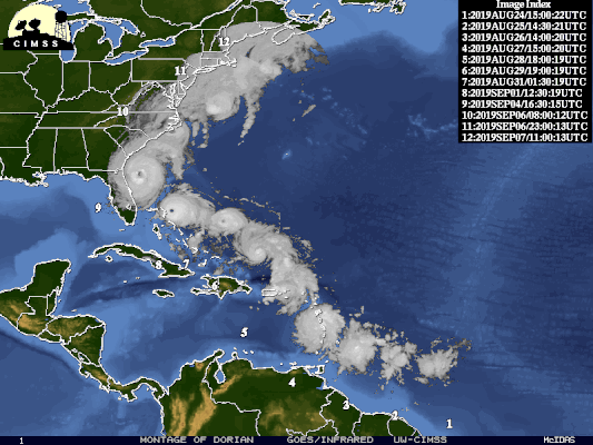
On August 24, 2019, a tropical wave in the Central Atlantic developed into a Tropical Storm named Dorian. This disturbance would serve as the fourth named storm, second hurricane, and first major hurricane of the 2019 Atlantic hurricane season.
What follows is an account of the atmospheric elements which provided Major Hurricane Dorian with enough boost to make the storm system the most powerful hurricane of the decade.
Dorian was a trickster right from the start.
Due to its minimal size, the National Hurricane Center had problems identifying Dorian as a tropical cyclone when it was still beyond the Lesser Antilles and over the Central Atlantic. Likewise, various models could not register or “resolve” owing to Dorian’s small size. Further, as Dorian drew closer to The Bahamas became the problem of its identification grew. Resultantly, models only considered the possibility of Dorian as a Category 1 storm that would move briefly north of The Bahamas.
Within 24 hours, Dorian went from a mere blip to a tropical depression with a closed circulation. This development and other factors made Hurricane Dorian The Bahamas’ most destructive storm to date. Because although small, Dorian was formidable, adorning a phenomenal eyewall configuration.
Remember when we watched the Winter Olympics and aspired to be ice skaters in our younger years? And remember when we saw the skater tuck in their arms, and was they able to spin faster and faster as a result?
The dynamics of tropical systems are no different. Dorian was lethal before we knew it could have been, with its strongest winds only a few miles from the center.
As a result, New Providence and other neighboring islands further than 30 miles away from Dorian received tropical-storm-force winds. In comparison, Dorian pounded The Abacos and Grand Bahama with unprecedented tornadic-force winds of just over 200 miles per hour at its peak.
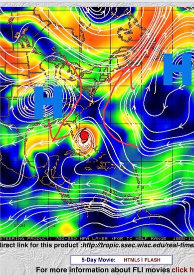
Hurricanes can steer themselves to some degree. Because they are low-pressure systems, they usually tend to follow invisible lines of low pressure. Almost like a heat-seeking missile, they move almost instinctively towards their targets. Whether they do so depends heavily on whether outside influences are weak enough for the system to move at its speed and direction.
In the case of Dorian, the storm system was mainly steered by ridges from several high-pressure systems that joined head-to-head higher in the atmosphere. On August 27, the National Hurricane Centre (NHC) depicted a track similar to the one that Dorian took, except that the storm’s center would only briefly move over Grand Bahama and Abaco and continue on its merry way. However, to our detriment, NHC was sadly mistaken.
According to Klotzbach (of Colorado State University) and McNoldly (of the University of Miami), the atmospheric steering of Dorian was ultimately interrupted, leaving it with minimal winds to propel it forward. Simply put, it was just a case of bad luck.
Research by Brandon Barton, a former post-doctoral researcher from the University of Wisconsin-Madison, suggests that wind speeds will likely decrease in time due to climate change. Further, reduced wind speeds are expected to play a critical role in the steering or movement of storms like Dorian. A reduction in wind speed may lead to the slowing down or stalling out of more intense storms across the Atlantic basin, which may ultimately result in even more devastation.
Dorian was gridlocked in place by two ridges associated with surrounding high-pressure systems. Imagine two people trying to push you in the opposite direction, but no one is overpowering the other. The same thing occurred with Hurricane Joaquin in 2015, which devastated the Central Bahamas without moving for almost two days. As a result, Dorian’s damaging winds remained over Abaco and Grand Bahama for 2 1/2 days.
One of the most unpredictable factors of Dorian, which has yet to be explored fully in determining the strength of a storm, is the effect of sea surface temperature. Considering that warm waters serve as the fuel for these systems, Dorian went through rapid development after it left Puerto Rico as a Tropical Storm.
Although models predicted that the storm would become a Category 3 hurricane before impacting The Bahamas, Dorian quickly outpaced those predictions. Within four days, Dorian became a Category 5 Hurricane, one of the most intense on record in the Atlantic, just before making landfall on Abaco.
Why were our waters so warm during this time? Seeing that the storm did not move over the banks along the island chain but rather along the deep Atlantic ridge to our east, we can discount shallow waters as a reason. However, here are three possible factors:
- Summer heating – although we get more sunlight in June, the water temperature usually reaches its peak 2 to 3 months later. (Dorian passed over waters with temperatures around 86°F/30°C in The Bahamas.)
- El Nino – August 2019 was the end of an El Nino year, where Bahamian waters are also anomalously warmer than the average sea surface temperatures.
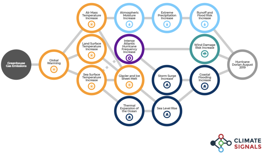
- Global Warming/Climate Change – Research has yet to conclude the full magnitude of these two factors on tropical oceans. However, 2019 was another record-breaking year of daily maximum temperatures across the globe.
In the expert opinion of both Klotzbach and McNoldly, linking one storm to climate change can be challenging. However, one can use patterns to show how storm systems are changing. The Fourth National Climate Change Assessment has highlighted that predicted hurricanes could become more intense and destructive as fuelled by a warming climate.
Since 1980, the number of Category 5 storms has tripled. In the past four years, the Atlantic basin has experienced five storm systems that have achieved at least a Category 5 status. All of them have been primarily due to warming sea surface temperatures.
Hurricane Dorian has defied the odds to become one of the most memorable storms for all the wrong reasons in the history of The Bahamas. While debates will rage on about how and why Dorian strengthened, the path it chose, and the number of records it surpassed, Dorian will forever be remembered as the storm dubbed, Category “Hell” by the United Nations chief Antonio Guterres.
The Inter Development Bank (IDB) report estimated that the total cost of the impacts and effects from Dorian on The Bahamas was pegged at $3.4 billion, with 29,472 persons directly affected by damages to their homes and assets.
The controversial topic of the number of deaths derived from Dorian remains a hot-button topic, with loved ones still fuming about the method implemented by the government in the burial method utilized.
A lifetime of tragedy can now be attributed to this storm. The decimation of a country is the pain that this hopefully once-in-a-lifetime storm left on this island nation known as The Bahamas. This country is often known for its warm, tropical waters as a substantial asset in attracting tourists to its shores. However, one unwelcomed guest that was attracted to its waters was a hurricane called Dorian. And Dorian will forever be etched in the annals of Bahamian and world history as one of the deadliest and costliest storms of all time.
For the official Major Hurricane Dorian report from The Bahamas Department of Meteorology click here.

Alexandria J. Adderley is a Bahamian Aeronautical Meteorological Officer. She has been with The Bahamas Department of Meteorology for seven years. She currently hosts a Research Blog dedicated to weather and nature.
Ian V. McKenzie is an Aeronautical Forecaster and has been employed with The Bahamas Department of Meteorology for 27 years. He has an ASc. in Geography and a BSc Distinction in Small Island Sustainability: Environment & Ecosystems Management- Marine Science.
Charvari Watson-Rahming is a trained Aeronautical Forecaster at The Bahamas Department of Meteorology. She has been working in the field for 6 years and served as a former teacher at the Ministry of Education.